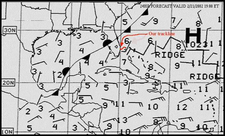
In the above weatherfax image, there's a little curved red line from the coast of Florida to the Grand Bahamas Island. This little curved line represents the path our boat took as it headed to the Bahamas.
Yes, it's S-shaped and no, we were not drunk.
The path is curved because of the effect of the Gulfstream. The trick is to guess the average speed of the Gulfstream (which we figured to be about 2.5 knots / about 3 mph). You then account for this drift by aiming upstream of your targeted landfall. We figured our boatspeed to be about 5 knots through the water (about 6 mph), so we steered about 25 degrees higher than the direct course of 100 degrees magnetic -- thus, we steered about 125 to 130. To start off, the Gulfstream near the coast is weak, and our boat actually tracks close to the 130 degree heading. Then, quite close to Florida, the Stream kicks in full force, with over 4 knots of current, and we are swept more towards Scotland than the Bahamas. At this point, one must resist the urge to point one's boat directly at one's destination, as doing this will result in the boat eventually pointing dead into the Gulfstream current, making very little progress towards the destination while plowing into the wicked current. We do confess that, mid-Stream, we thought we were going to miss West End, Bahamas, by 20 miles. Finally, as one exits the Gulfstream, the boat starts making progress along the chosen heading again. The resultant course looks like the curved line depicted on this weatherfax. In our case, our navigation worked out perfectly, and West End hove into view on our port bow about 10 hours after departing Florida.
What we did not anticipate was the weather. The weatherfax you see has a little "arrow" over the Grand Bahama island. The arrow is flying to the northeast, indicating that the wind should be moving towards the northeast (coming from the southwest). There are two vanes on the arrow - a long one, depicting 10 knots of wind (about 12mph), and 5 knots (about 6 mph), totaling 15 knots (close to 20 mph). The nearby "6" indicates the significant wave height (height of most of the waves).